Abundance of Ashtons
Long Ashton is the "traditional" village with Ashton Court being the "big house" ...
... set in Ashton Park, both open to the public.
Bower Ashton was historically a hamlet in the parish of Long Ashton. In medieval times the area was owned by St Augustine's Abbey, but following the dissolution the Smyth estate, Ashton Court, was established by John Smyth, a merchant from Small Street in the city, in the 16th century. In the 19th century Sir John Henry Greville Smyth rebuilt Ashton Court Mansion along with a now demolished Dower house on the present site of the School of Creative Arts, Part of the University of the West of England.
No 1 son studied creative "stuff" at Bower Ashton.
Maps of that era show a ropewalk, Frayne's Colliery and Ashton Vale Iron works, adjacent to the Portishead railway line.
Ashton Gate is the name of Bristol City's footy stadium (above top right), the area being named after a gateway leading to and through the Ashton Court Estate. It sits at the junction of North Street and Coronation Road ...... and is beautifully preserved but very much out of place amongst more recent (and less attractive) property.But it was the Gate to Ashton at the Bristol end of Ashton Road. Nowadays, Ashton Road fizzles out at a dull and uninspiring dead end ...... only to re-appear on the other side of the Brunel Way mega-junction.But we digress. Back to Ashton Vale, NOT approached via Ashton Vale Road (on map above), obviously! The housing to the left of "The Batches" (no, fbb doesn't!) was being developed pre- and post WW2 as Ashton Vale housing estate. Of course things have moved on a bit by 2022!
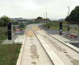
Long Ashton is by-passed by a new chunk of the A370 (RED), the A4174 is also new (GREEN) and the other "green" route is Winterstoke Road, leading from City southbound. The M2 Park & Ride (BLUE) is the one served by the super new guided busway which doesn't go round corners.
Well, the road does but the guided bit doesn't!
Note the railway curving round and exiting the map on its northern edge. One day that will be the re-opened branch to Portishead. There was a station at Ashton Gate, located roughly where the road junction squodge is, top right.
The line to the right made its way round to the Bristol Docks.
So back to the Ashton Vale estate.
Things to note are the footy stadium top right, the Portishead railway exiting north, the main line to Weston-super-Mud and points west crossing along the bottom, the not-quite guided busway in shiny white and Winterstoke Road running past the stadium.
The main "way in" is via Ashton Drive off Winterstoke Road (GREEN) which, on the map, looks a bit constricted but is actually good and wide ...
... until you come to the bridge under the Portishead line.
It is very low and very thin.
The other "way in" is via South Liberty Lane, also impeded by the thinness of ferroequinological engineering. This time it is a very thin bridge ...
... where it goes OVER the Portishead line.
This route takes you to parts of Ashton Vale that were built pre WW2, the original beginnings.
Perhaps it is this unhelpful access that has led to the residents feeling a sense of isolation, hence the tag "forgotten".
Not completely forgotten, however; there is a stop on the M2 guided (sometimes) busway on the northern edge of the estate.
Google Maps hasn't found its way to the stop and only shows the infill housing under construction, but ...
... Google Earth shows the new road, as yet unvisited by Streetview and the stop just above the red brick block, upper right. And fbb's shot of the busway from a bus is actually of the Ashton Vale stop where guidance ends to allow the buses to go round the corner!.
Having established the background, we can more on to look at the "traditional" bus services to Ashton Vale.
Next "Forgotten" blog : Wednesday 26th January


No comments:
Post a Comment