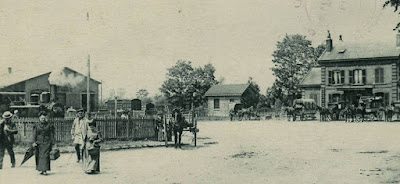
La Compagnie des chemins de fer du Nord, concessionnaire depuis le 26 juin 1857 d'un chemin de fer d'Amiens à la ligne de Creil à Saint-Quentin, se voit préciser le tracé entre Amiens et Ham par le décret du 22 septembre 1861. Elle met en service la section d'Amiens à Tergnier via la gare de Ham, le 1er juillet 1867.
Effectively the "Nord" railway company filled in a gap in its network by "décret" (in UK it would have been an Act of Parliament) by construction a line from Amiens to Tergnier via Ham.
The station was similar in style to others along the line with a wooden platform canopy and limited facilities for goods, later much extended.
Then it all gets rather complicated/
La gare va ensuite prendre de l'importance, avec l'arrivée de lignes de chemin de fer secondaire à voie métrique qui permettent des correspondances et du trafic marchandises.
Several secondary lines converged on Ham adding significantly to its importance.
La première est une ligne d'Albert à Ham via Péronne, mise en service en 1889 par la Société générale des chemins de fer économique.
This metre gauge line has disappeared from modern maps and aerial photographs but is shown on the diagram below.
fbb's guess is that the line followed the banks of the Somme River and Canal as it approached Ham.
Road D17 between Offoy and Martigny looks suspiciously straight and might have taken the trackbed of this little line.
Maybe one of our readers has greater knowledge and research ability than fbb. It wouldn't be difficult.
The Société générale des chemins de fer économique ran several networks of secondary lines.
En 1912, la Compagnie des chemins de fer départementaux de l'Aisne (CDA) met en service les 21 km de sa ligne secondaire à voie unique et écartement standard, de Saint-Quentin à Ham.
This line is also closed but many of the station buildings still remain in private hands.
Again, tracking the route at ground level is almost impossible once the former stations are left behind.
Today a train service runs from Amiens to Saint Quentin calling only at Ham, taking a triangular junction ...
... to join the line travelling northwards from Tergnier, a very different route from the original. Saint Quentin is he red blob far right.
La même année une deuxième ligne à voie métrique rejoint Ham, lorsque la Compagnie des Chemins de fer de Milly à Formerie et de Noyon à Guiscard et à Lassigny (NGL) ouvre les 11 km de Guiscard à Ham.
Once again evidence is lost but a postcard shows the narrow gauge line (left) and the main line to Ham at Formerie station.
We all know of the horrors of The Somme and this appalling conflict destroyed large parts of Ham including the station.
A temporary station was soon constructed and services restored.
The present station building was the permanent replacement.
One feature of the station hitherto unblogged it its frescoes, high up in the waiting room area. Here is a representation of the sugar industry ...
... and nearby, the castle.
They were painted by Marie Fernande Van Driesten Parys who was born in Lille in 1874.
One final sadness. Note the picture of Ham Château above.
This magnificent edifice was blown up by the Kaiser's army in retreat in 1917.
Only the remains of the gatehouse still stand ...
... just a short walk from the railway station.
We must look at buses as well. Probably tomorrow.
Next Ham blog : Thursday 16th November


No comments:
Post a Comment