
To See The Problem ...

... you could download the Oxford Circus "spider" PDF and work it out for yourself. If you are not a well trodden London explorer you might find this a bit of a magical mystery tour. Suffice it to say that Transport for London (TfL), as part of their on-going policy to remove all maps from public gaze, have withdrawn lots of spiders and greatly reduced the scope of others as they are updated. Now, instead of showing the whole route, detailed information ends at an arbitrary boundary - e/g/ for the Central area, not too par outside the Congestion Charge boundary.
Assuming that few passengers have the stamina to make long journeys by bus from Oxford Circus, this may be a good idea. But it might mean that there is now no need to have a spider at all; you could have a real map, an accurate map which shows places in their correct geographical relationship.
Have a look at this extract from TfL's re-jigged spider for Oxford Circus. In fact, Edgware Road Station is a short walk due West of Marylebone, about as far west as Baker Street is to the East.


Maida Vale is some distance North west of Edgware Road. Then there's the Paddington area. In fact Lancaster Gate is very close to Paddington ...


... so much so that those "in the know" toddle a few hundred yards to catch a Central Line train rather than taking the Circle/District to Notting Hill Gate and changing.


A geographical map would show this and make travel decisions much easier. Outside the core area of the former spider, diagrammatic lines will suffice as few will be travelling that far from e.g. the Oxford Circus hub.
So, where to start.
First, gather your resources, your sources of information. Probably the best start in one of the maps that TfL no longer deigns to produce, in this case the "Central Area" map.

Of course, things have changed since it last appeared, so your noble cartographer needs to keep his aged wits about him. The map shows route C2 as running via Albany Street ...
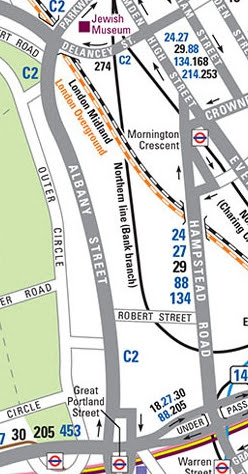
... and the 88 via Hampstead Road. Now the 88 has replaced the C2 and runs via Albany Street, close to Regents Park.
The route maps for each service on the TfL site can help a bit ... ... and TfL's list of stops is available, but hard to use.
 Google Streetview can help with checking individual stops ...
 ... provided the noddy car clicks its camera shutter at the right angle!


Finally, you can match it all up with the excellent Collins Street Map book. fbb found himself referring to all the disparate information sources, and even then found some things difficult to resolve. But the first results are encouraging.

Here is Marylebone ... ... here is Paddington ...


... and here is the revised 88.

Put all the variegated effort together and this is what you get (click on the map below for an enlargement). If grappling with enlargements is not your desire, here is a chunk that includes Marylebone and Paddington.
 By using the colours and clear route numbers, we can cut out some of the clutter and make the map easier to follow. Anyone who can use a map is not an idiot; they understand that route 7 in purple will be the same as the purple line. Users do not need route numbers scattered in very small print liberally over the map.


Fewer is finer says your noble designer.
There is an important "mantra" for public transport information; "You can either be comprehensive OR comprehensible, not both."
There is a question as to what to include and what to leave out. Here, more debate with potential users is needed BUT most users will find it easier if the graphics are uncluttered and simple.
Harry Becks original Undergound maps was thus, and look what we have done to it today! Sorry Mr Beck, honoured and revered Sir, we do seem to have lost the plot by over plotting!

A slightly lesser challenge (surely) is to add the outer bits of the routes which will remain diagrammatic.
More tomorrow.
A Little More On The 484 After crossing on the Wightlink ferry (two crossings, one for each car) the cars were taken to the sidings at Sandown where they were hauled off the low loader ...
 ... and coupled together on the rails, model railway style! This was in the darkness of the early hours.
 The two car train then travelled under its own battery power ...
 ... to the depot at Ryde St Johns Road, where it settled down for the night after a very exciting day for a two car electric train.
 And here it is compared with the existing luxury stock back at Sandown.
 Thanks to Senior Island Correspondent, Alan, for sending the picture and even more thanks to chum and former colleague John for getting up in the dead of night to watch the transfer from low loader to depot.


Nothing much ever happens on the Island, so this must have excited the locals nearly as much as when Queen Victoria bought Osborne House.
Final Spider Episode plus : Wednesday 25th November
No comments:
Post a Comment