

St James The Square had become more of a triangle by the early 1900s as seen above; with a tram approaching from its nearby terminus. There is, just about, a match with today's view.

The gabled building at the apex of the "square" is still recognisable as is the red brick church in he background (above centre right); but everything on the left of the older view has gone to make way for the dreaded motor car.

The former Methodist Church is now owned by a firm of solicitors ...
 ... and has been rebuilt and/or extended at the corner.

But essentially "The Square" remains the road junction where Weedon Road (the old A45) veers left and Harlestone Road (A428) veers right.

Weedon Road, of course, is the main route from the town to the M1 and, some years ago, the council decided to "improve traffic flows" by doing something dramatic with Spencer Bridge Road (map, centre right). A gap was blasted through Sandhill Road ...

... (once the home of our esteemed Northampton correspondent) and properties on the two main roads to "improve the traffic flow" by providing an alternative route from town to the M1. The consequence, of course, is that even more traffic uses both roads and poor Jimmys End is almost lost in a sea of motor vehicles, moving slowly!

The effect of this on public transport is not good. Buses travelling from the town centre used to share a common stop on The Square. Now, Weedon Road buses (to Duston and Daventry, for example) are pushed round the corner away from the right hand fork ...
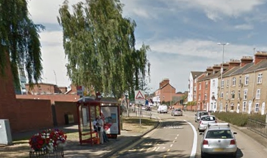
... but still reasonably close to the action. Buses via Harlestone Road and on the busy routes to Kings Heath Estate have been pushed out of the centre of things, to outside the former Methodist Church.

On journeys to town, however, the traffic planners have contrived to provide one stop for all services.

Well done!
To achieve this, buses from the Weedon Road (take a look at the coloured map enlargement above) now turn left into the extended Spencer Bridge Road ...

... and by using a dedicated bit of bus lane ...

... turn right into Harlestone Road and thus on to the stop.

Clever eh?
Maybe. But at busy times (and that is most of the day, Monday thru' Saturday) inbound and outbound manoeuvres are fraught with delays as traffic builds up at the junctions.
So the Council planning people have come up with a cunning plan for which work has begun this very week.
But it all used to be so simple.
 Sigh! We are, nevertheless, all very excited about the developments. NOT; as we shall see tomorrow.
But it all used to be so simple.

Next Jimmys End bus blog : Thursday 12th January
I hope this isn't going to be some tirade about how things were so much better in the past.
ReplyDeleteThe comment "it all used to be so simple" and a map from c.1963. That would've been when Northampton had a population of c.105k. It now has a population of more than double that.
The local services stopped at the Eleanor Cross (with doubtless a non-clockface array of journeys running through the sticks to Towcester). Now we have the sprawling 'burbs of Hunsbury et al. The south east extent was Midsummer Meadow.... Of course, we now have the sprawl of Brackmills (industry), Hardingstone, and Grange Park. That's all before we even look at the west and St James. Whereas Duston was a tiny village, it's now a large suburb with industry there too, plus the all the other developments in the intervening 50 years, of which more are being built now just off Harlestone Road.
Northampton is a much larger place than was probably ever envisaged. Is the road network enjoyable? No, and I've lived and worked there for several years. However, yearning for a world of simple rose tinted revelry, a 1950s idyll of pre EU simplicity where cricket was played on village greens and continually sunlit uplands that never actually existed, will always leave you disappointed.