Be Enhanced By Behance?
Behance was founded by Matias Corea and Scott Belsky in November 2005. The company initially relied on revenue, generating income by selling banner ads, job postings and later, 99U conference tickets. In May 2012, their first round of outside funding received $6.5 million from investors including Dave McClure and Jeff Bezos's personal investment firm, Bezos Expeditions.
The company was acquired by Adobe Systems for $150 million in December 2012. In 2021, Behance added a subscription feature for users to sell their tutorials and other services. It also added crypto wallet integration.
Users can sign up to Behance and build profiles consisting of projects. Both registered and unregistered users can view any particular project, as well as comment on them. Members of Behance can follow other users' profiles. Co-founder Belsky compared the first version of Behance's online porfolios with "project" structures as providing an organised art showcase, in comparison to DeviantArt and Saatchi's digital community.
To cut to the chase, the site seems to be a way for "creative" businesses to showcase their wares. So Mr Mike Hall has uploaded not one but TWO "Tube" maps. The most recent is a version of the 2022 map with a number of modifications. But the 2015 design is much more radical as we have seen when looking at the problems of Paddington.
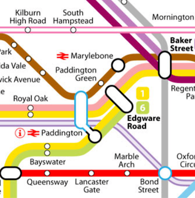
We can grasp something of Mr Hall's 2015 style from just this extract. We notice, for example, that he has renamed Edgware Road station on the Bakerloo Line. There are two separate Edgware Road station with no physical connection between them.
But before we look more closely at the Edgware Road stations, note that Mr Hall was proposing to number the underground lines, consigning their historic names to the rubbish bin of history. 1 is one end of the non-circling \circle line, the other is at Hammersmith. 6 is for the terminus of (former!) District Line trains from Wimbledon, given a lighter green than the rest of the District. Whilst numbers are the norm in most European cities (mais pas a Paris!), fbb can see a real "pitchforks at dawn" response from Londoners.
Note also the outlines of the interchange blobs. The LIGHT BLUE designates full disabled access whilst BLACK tells us there is none! Once you grasp the idea it is far neater than the clutter of wheelchair symbols on the official map.TfL goes a bit further by warning you that the jump from platform to train is not level in some cases. But would you call such inadequacies a step? Surely no worse than a kerb?
Edgware Road District, Circle and Hammersmith & City line station (much less clutter with line numbers!) is not located on the thoroughfare after which it is named.The station entrance stands at the corner of Chapel Street and Cabbell Street just off the Marylebone Road.Chapel Street (A501) runs off Edgware Road. The aerial view (above) shows a little bit of the station that maybe escapes the bleary eyes of the average commuter. Towards the eastern ends of the platform is a footbridge.Some accounts say that it has now been demolished but it hasn't - it is certainly well in place on Google Earth. The northern exit ...... leads out to Marylebone Road itself (but is no longer used?) whilst the footway to the south leads into Griffith House ...... owned by TfL and used by various departmental offices over the years. Here is the footbridge ...... and here is the exit to Griffith House.The walkway continued off at an angle to the left beyond the locked doors. No signs, these days, to an exit on Marylebone Road.
Between the station buildings proper and Griffith House there is one of these.Now it may look like a pile of disused containers fettled up as a piece of street art (as you do!) but, in fact, it is a new sub station for the Underground. Very pretty as substations go.
So where might the Bakerloo line station be hidden. TfL tells you!This takes you under the Marylebone Road flyover, across the lower deck of Marylebone Road (and the best of luck with that, buster) ...... where you will find the Bakerloo station almost on the corner.There is a similar verbal notice at the Bakerloo entrance ... ... directing confused passengers to the Circle (etc) line station, but, even better (!!), there is an on-line page which tells you how to do it by bus!
Edgware Road Station (Bakerloo line) to
Edgware Road Station (Circle etc lines) by bus
The bus journey time between Edgware Road Station (Bakerloo line) and Edgware Road Station (Circle, District and Hammersmith & City lines) is around 2 min and covers a distance of around 842 feet. Operated by London Buses, the Edgware Road Station (Bakerloo line) to Edgware Road Station (Circle, District and Hammersmith & City lines) bus service departs from Edgware Road and arrives in Lisson Grove, Edgware Road Praed Street. Typically 2944 buses run weekly, although weekend and holiday schedules can vary so check in advance.
Well, it might be safer than the walk route!
Mr Hall has renamed the Bakerloo line station as "Paddington Green" but, maybe, that adds to the confusion which could be easily (but not cheaply!) solved by building a proper subway between the two lines.
So innovations on the Behance map now include line numbers and station renamings.
Then we move to the Overground.Sensibly, Mark Hall uses different coloured "cased" (hollow?) lines for each Overground route. Each line is then lettered.
Which pops another idea into fbb's head.
Why not use "U" plus number for the Underground lines and "S" plus number for the Overground etc, The Elizabeth Line line(s) could be "S1", Thameslink "S4", Crossrail 2 "S2", leaving S3 for Crossrail 3 linking The Metropolitan line "extensions" from Watford, Amersham etc with deep level tunnels joining with the South Eastern suburban network currently running out of London Bridge.
Well, an old man can dream!
The rest of the Overground could then be "S" numbered to follow.
There are other developments in the 2015 experimental map, notably the separation of the West End "branch" from the City "branch" of the Northern Line.Our cunning cartographer says that it is coloured "GOLD" but a less wishy-washy tome might be more helpful. How about DARK GREEN?
Unfortunately this excellent experimental Tube map is not available as a PDF, so a more detailed set of extracts are unrecoverable from the low resolution JPG available on line. But from the extracts given on the Behance site, fbb gives it his top marks out of all the long list of recent attempts to out-Harry Harry Beck.
Sadly, it also comes from an era when Thameslink was very much a detailed glint in the eyes of the rail planners, even if it was well past its original label of Thameslink 2000. It certainly was not considered relevant by TfL until much more recently.
Mr Hall's 2022 map is less revolutionary but well worth a look.
fbb will oblige as soon as practicable.
First, the footbridge! It appears that the girders for the link from footbridge to the office block had been deemed unsafe but they have been/are going to be replaced - so all is well with this Underground oddity.
The office block itself is due for a major refurb. The light-well (hole through the innards of the building) is due to become an atrium (so there!) - i.e. there will be a lid on the hole.
More significantly, three extra storeys are to be added.
But the most interesting snippet, unknown by fbb, is that at one time (certainly in the mid 70s) London Underground had a poster shop located in the building and accessed by that footbridge.
Next Variety blog : Sunday 8th January


Griffith House was also where the LT medical facility was based.
ReplyDeleteIn 1990 I applied to be a bus driver with LT, and had to have a medical examination first. I was told that my eyesight was defective, and I wouldn't be able to pass the PSV drivers test.
I then pointed out that I wore corrective glasses, and was deemed OK when I passed my test in 1979. After 30 minutes of referring my case up to the Chief Medical Officer (!), I was told "oh . . . all right then, I suppose!"
LT always did things its own way . . . I wonder how many prospective drivers were refused necause of excessively high standards.