Correspondent Bob contacted fbb a few days ago with regard to one of his not infrequent visits to the wonderful Chesterfield Market. As well as a superabundance of traditional outside stalls ...
... there is also the magnificent Market Hall complete with tower and clock. The indoor hall was refurbished and re-opened in 2013 and looks posh but intriguing.
Chesterfield had three railway stations as per this map from the early 1950s.
The one remaining is Midland (upper right) on the former Midland Railway's main line to Sheffield.
It has change quite a bit over the years!
A little nearer the town centre, just off Brewery Street was Chesterfield Central.
This was on a loop line off the main Great Central route, running from Temple Normanton to Staveley.
This was on a loop line off the main Great Central route, running from Temple Normanton to Staveley.
The line lunged into a tunnel not quite under the church with the twisted spire.
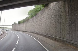
Almost all evidence of the GC line is now lost having been overcome by the super road for the A61.
The tunnel lies hidden behind the retaining wall just under the Brewery Street bridge.
There is what looks suspiciously like an access shaft on top of the wall.
The northern portal still portalling is pictured here on the last day of use.
But if you are very inquisitive, you can find the southern portal.
Walk down Hollis Lane passing the Galleon Steakhouse on your right and, on your left at the bottom ...
The northern portal still portalling is pictured here on the last day of use.
But if you are very inquisitive, you can find the southern portal.
Walk down Hollis Lane passing the Galleon Steakhouse on your right and, on your left at the bottom ...
... is a ramp behind locked gates which leads down to said tunnel. Some urban explorers have been down there.
Creepy, dangerous and probably illegal.
Creepy, dangerous and probably illegal.
Which leaves the third (and least known) station called Chesterfield Market Place. In the map above it stands centre left.
The problem in tracing this terminus (Lincolnshire, Derbyshire and East Coast Railway) that its approaches have disappeared completely AND the road network has changed. The location can be gleaned from this painting.
Straight ahead (behind the corporation bus) is the market hall. To the right of of bus is the distinctive "half-timbered" building ...
... now (no surprise here) a Wetherspoons pub/nosh house. Ironically the present end-on car parking bays mirror the arrangements outside the station building of old. The line closed in 1951.
The approaches to all three Chesterfield stations come into close proximity to the south of the crooked spire. This old photograph might help.
The Great Central runs under the pedestrian footbridge then under the Midland line. The Midland runs across the low arches to the left then under the line to Market Place which crosses above just beyond the line of cottages.
Horns Bridge, he big brick arch over the old A61 junction, ...
... was the last vestige of this approach line to remain.
In fact one small part of this complex weave of railway infrastructure can still be traced. The Midland Railway had a branch line to Brampton (a k a Brampton Wharf).
Oddly, when the super-duper road network was built the bridges for this unused line were also replaced.
They now carry a footpath and cycleway!
Have you followed all this? Probably not!
But open up the maps, look at the pictures, take a couple of strength pills and you might sort it all out. fbb can only apologise if he has failed to communicate all this stuff with 100% accuracy and adequate clarity.
Tomorrow it is Chesterfield's bus stations that feature and, indeed, the real reason for correspondent Bob's e-mail.
Next Chesterfield blog : Friday 31st May


https://www.youtube.com/watch?v=CfoOjsYc7dk
ReplyDelete
ReplyDeleteI’m glad to see it featured here,Nice blog, I really apprecialte the way you are sharing your exwperiences,Thank you for sharing about this information. That’s nice and interesting, I like it.
http://www.irvingtaxi247.com
https://www.dhesirealestate.ca/'s 'Price Reduction Alerts' notified us about a hidden gem in Castlemore that had just dropped $30K - we jumped on it and got an amazing deal!
ReplyDeleteIt’s easy to stay informed about the Brampton market thanks to brampton-homes.ca and its consistently refreshed property details.
ReplyDelete