He was Home Secretary in the UK Government, charged with developing a penal colony in Australia. The name Sidney originates from the French Saint Denis!
The flag was duly planted on a quiet cove ...
No 1 son and his Mrs visited Sydney in an antipodean holiday last year and fbb duly reported their goings on. Sadly No 1 son did not really grasp the transport network of the City, his pictures recording merely the journeys the wedded twosome took during their short stay.
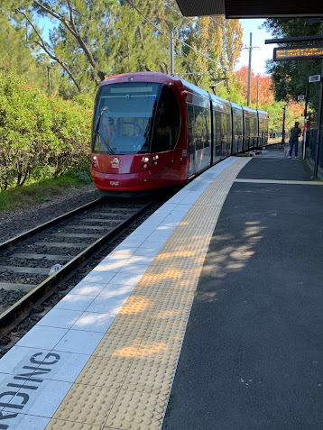
The most recent network to be added to Sydney's public transport facilities is "Light Rail" which fbb would call Trams ...
... although the stops have a flavour of proper stations.
Again the
L network map is a bit too big to squeeze in a blog post, so an extract is shown below.
The L1 zooms off westbound to a terminus at Dulwich Hill. Typically the L1 runs every ten minutes ...
... every six at peak and every 15 evenings and Sundays. At Dulwich Hill, the Light Rail ...
... made connection with a suburban line ...
... via a quaint, and probably old, wooden station. Now, via a posh new footbridge and lifts ...
... you can join Sydney's very new
M etro.
Only one line of a proposed more extensive network is open. The history of this one line is convoluted and mired in politics; with cancellations, reinstatements and more cancellations.
One scheme was cancelled in 2010 with a change in New South Wales Government after 410 million Ozzy dollars had already been spent. OUCH!
In mid-2012, the newly elected Coalition government announced Sydney's Rail Future and the NSW Transport Masterplan Under this proposal, the North West Rail Link would be built as a single-deck, privately operated metro connecting to a future second harbour crossing. These plans received criticism on the basis that they might not have the capacity of existing double-deck trains and concerns over the inability of trains on the existing network to use the new crossing. Later, the route was extended and the name changed to Sydney Metro.The first section opened in 2018 from Tallawong (what a glorious Oz name and a stuning station!) ...
... to a stop north of the harbour at Chatswood.
Click on the map for an enlargement. Just for amusement, notice a station called Epping.
The line is fully automatic with platform doors, of course.
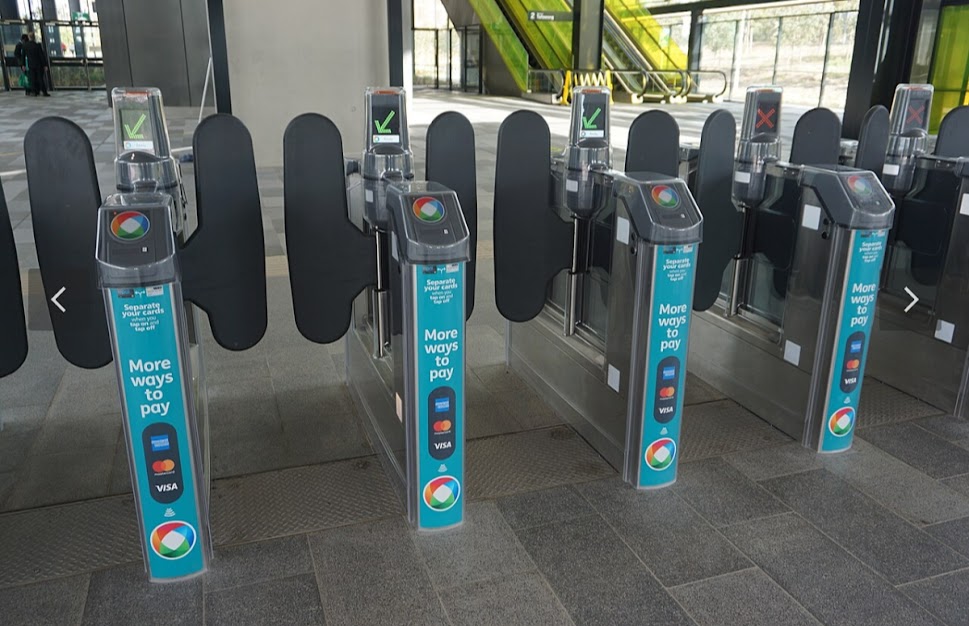
Ticket "gates" ...
... and machines are standard.
The ambiance is very similar to London Overground with inward facing seats and oodles of standing room.
Frequency is every 4 mins at peak; every 10 mins off peak and Saturday daytime, evey 15 min evenings and Sundays. And, unlike most Metro systems worldwide, you can get a full PDF timetable.
Well done New South Wales Transport Authority!
Extended Metro
What prompted this blog was the news that a major extension has recently been opened.
It runs from the previous terminus at Chatswood, then under Sydney Harbour and on to Bankstown. Notice Canterbury and Dulwich Hill, even a station called Sydenham.
There is also a stop called Waterloo.
So here's a thing.
You can catch a Sydney Metro from
Epping to
Sydenham via
Waterloo, a sort of Australian Crossrail 2!
Much of the route is on reconstituted rail line with newer underground sections. (See below)
A second route (in greenish blue on the above "new line" map) is under construction with line 3 to serve a brand new airport out west in an advanced planning stage.
Interesting name for an airport.
Nancy Bird Walton, AO, OBE (16 October 1915 to 13 January 2009) was a pioneering Australian aviator, known as "The Angel of the Outback", and the founder and patron of the Australian Women Pilots' Association.
In the 1930s, she became a fully qualified pilot at the age of 19 to become the youngest Australian woman to gain a pilot's license.
The airport will be splendid when it is finished!
Now what might an aerotropolis be (see new line Metro diagram above)?
Back to the recent extension to Bankstown.
This was originally part of "Train" line T3 ...
... which has been taken over by the Metro. Obviously this rather minimalist train branch (picture of Bankstown below in 1968) ...
... has been well upgraded to Metro standards ready for M1's arrival.
The Other Shiregreen Half?
Yesterday, in amongst an attack of the screaming abdabs courtesy First Bus and Travel South Yorkshire, fbb managed to work out that the the current 75 (anti clockwise) round the Shiregreen estate "circle" was being unhooked and diverted elsewhere. See above for long term traditional (left) and upcoming revision (right).
As a minor aside, from September 1st, passengers from Bellhouse Road, used to flagging down a 76 to City will now need to understand that their bus is now a 75. Probably they will never notice.
So what has happened to the 76 (clockwise)?
Although the 76 is unchanged south of the city centre it has vanished from Shiregreen.
Here is the PTE's explanation
Services 47, 48
From 01 September these services will be introduced, providing journeys between Shiregreen, Sheffield and Herdings in a circular loop.
Journeys operate every day of the week, and up to every 10 minutes (combined) on Monday to Saturday daytimes. These services partially replace services 75 and 76 in Shiregreen and services 1a and 11 in Gleadless Valley.
Here is the First's explanation/
Services 47 and 48
These new services will operate from Shiregreen, serving Gregg House Rd, Hartley Brook Rd and Sicey Ave - via Firth Park, Firth Park Rd, Firvale, Burngreave, City Centre East Bank Rd, Newfield Green, Hemsworth and Herdings.
There is more obvious detail for routes to the south of the city.
At First glance, however, that looks like the western leg of the Shitegrenn circle, some of it unserved by the re-jigged 75.
Sensibly, fbb will quietly ignore the routes south of the city centre for his sanity and that of his readers. He will return to this change when he has recovered from the work on today's and yesterday's offering.
Does the timetable help? Not really!
The PTE's version is a hopeless source of necessary information with no point times between Shiregreen and Firth Park and, to be tackled later, no indication of route round the loop in the south.
First's timetable is not much better. It has too much white space and therefore is more difficult to read, but ...
... at least it does indicate which way the buses go in the south; Herdings then Hemsworth OR Hemsworth then Herdings. But why do we hate those unexplained "stop codes"?
Some readers will be screening at their screams that First does have a map of the 47 and 48 on its web site. So it does, but it appeared later than fbb's tortured research, so the old man did not, at first, have the benefit thereof.
But he did turn, hesitantly to the PTEs route and/or stop list, a weird mixture of both - that is not a complete list of either!
The above is as quoted for the 47. We first notice that the 47 gets to Firth Park via the former 75 and 76 route (DARK BROWN). Whilst the 75 and 76 now run via Rock Street (GREEN 95s on the maps below) which is, confusingly, the way Shiregreen buses (including the former 47 and 48) have gone since pre WW2.
Likewise the new 47 uses Firth Park Road ...
... rather than the old Shiregreen route via the Northern General Hospital.
Confusing, innit?
But, again according to the PTE, the 48 serves exactly the same roads in Shiregreen as the 47.
Cleverly (?) fbb has recreated the route in Shiregreen for his readers who have not yet lost the will to live.
The lollipop is traversed in a clockwise direction.
This means that the original circular Shiregreen loop of fond memory and long long history no longer operates. There is no loop round the whole estate.
That will bring cheer and rejoicing to residents (NOT) who will have lost the opportunity of going "the long way round" (on the traditional loop) when the frequency is low, or, indeed, by just getting on the first bus that comes if it is raining or the shopping is burdensome.
This route is confirmed by the First Bus late-arrival map.
So fbb did get it right.
In the past, if course, the original 47 and 48 ran alternate ways round the estate "loop" and there will be many, many residents who will assume that the same will be happening from 1st September. First Bus even introduced its early reporting of the plans at "consultation" (snigger snigger) as "returning to the popular 47 and 48 routes of old" which it isn't!
What Has Happened to the 76?
Readers with a brain of monstrous memory skills will, of course, remember that fbb covered the proposals for the 76 when writing about the "consultation". Effectively instead of striking clockwise through Shiregreen, the 76 assumes the route and operation of the former 95 and 95a in the north of the city.
And this is exactly what fbb was expecting. But is it and does it?
Keen readers can pick out the 95/95a on the two maps quoted above and you would expect the new 76 and 76a will follow the same route via Rock Street and Hucklow Road just like the new 75 and 75a.
Oh no they don't!
The 76, 76a and a 76e (an evening portmanteau of the 76 an 76a) use the route via Burngreave just like the old 76! But then, to confuse everyone, they rejoin the new 75, 75a to serve Northern General Hospital.
Surely both 75s and 76s will then run via Hucklow Road to Firth Park? This is the way ALL buses have gone since time immortal to get from the Hospital to Firth Park - including the old 47 and 48 and the even older 150 and 151.
But to really bamboozle passengers, the new 76 and 76a do something utterly unpredictable (and probably utterly useless).
Instead of forking right on Hucklow Road like this outbound Stagecoach service 1 ...
... and the recent 95 and 95a, the 76 and 76a go straight on up the hill, a continuation of Barnsley Road.
As Google Streetview shows us, this road is packed with potential customers ...
... having previously only carried service 65 then 165 then 265 and now 2/2a between Sheffield and Barnsley.
The 29 is what is left of a through route from Sheffield to Huddersfield and Halifax once numbered 68 and later X68.
Next our errant 76s hangs a right ...
... turning south into Stubbin Lane ...
... with an inbound Stagecoach 1 ahead. Our 76s approach Firth Park from the north ...
... and here is the route on First's map - enlarged ...
... and showing no useful road names.
From Firth Park the 76/76a picks up the 95 and 95a route to Meadowhell.
Whilst First Bus have given us a complete map ...
... it is combined with the 75 with which it now has little affinity except perhaps unchanged on the south side of the the city.
Different colours for the two routes would have been sensible - especially as the timetables are shown separately.
Somebody may know why one 76a starts from Tinsley at 0804 and offers no return journey; but fbb doesn't.
There is no explanation on the PTE non-leaflet ...
... but, helpfully (?), it does materialise on the route description list. Or is it a list of some stops in an arbitrary order?
What is certain is that the poor people of Sheffield will get no printed material to help them with this almost crackpot series of changes.
fbb asked an expert and experienced ex manager what he thought was motivating these weird timetable "improvements".
His reply, after some explosive expostulation, was ...
... that somebody somewhere had told an expensive computer system run by expensive consultants (who had never been to Sheffield) to evaluate several huge buckets of data, and the system has come up with an idealised re-jig of the network with no reference to current actuality or to where people really want to go.
QED!
That's modern bus management at work!
So more passengers lost to First Bus then?
fbb will leave the changes to the south of the city until next week as his elderly brain has come close to blowing several fuses.
Gibber gibber! Order some more tranquilisers!
Next Variety blog : Saturday 24th August


.jpg)


.jpg)

.jpg)

.jpg)
.jpg)
.jpg)


.jpg)


.jpg)


.jpg)
.jpg)

.jpg)


.jpg)
.jpg)

.jpg)
.jpg)
.jpg)
.jpg)

.jpg)
.jpg)
.jpg)
.jpg)
.jpg)
.jpg)
.jpg)
.jpg)
.jpg)
No comments:
Post a Comment