
See What's Built On Tiny Milton

Travelling south from Abingdon you would naturally take the A34; but, if you missed your turn somewhere, you might just happen on the tiny picturesque village of Milton.
Entering from the north you would miss St Blaise Church ...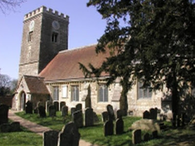

... set back in woodland and clearly designed to serve the needs of Milton Hall ...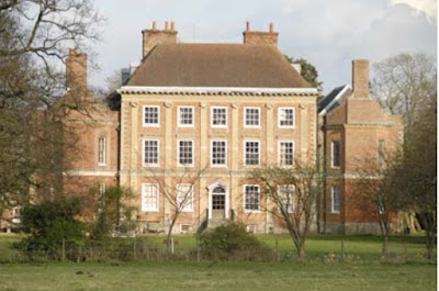

... rather than the lower orders in the village. Also "round the back" is the village pub which has enjoyed various names over he years and is now "The Plum Pudding". Nearby, but back in the High Street, is the village bus stop c/w shelter and "both sides of the road" flag.
 There is the Methodist Church, old on the left, now a private dwelling, and "new" on the right.
 Then you may espy this building.
 The posting box gives the game away. This was the village shop and post office and once looked like this.
 The village has more than its fair share of quaint cottages ...
 ... and quaint corners, this one at the end of Pembroke Road..
 You may struggle to find this row of terraced hereditaments (below) ...
 ... but they are still there although much rebuilt and prettified at the far side of a car park.
 The black-and-white picture is captioned "the entrance to RAF Milton".


Didcot was of huge strategic importance during both world wars. It had very good rail links. East-west is the Great Western main line; off to the north you get to Oxford and Birmingham and the little line to the South ran via Newbury to Winchester - and is no more.

Although the OS maps show nothing (for security reasons?), a vast swathe of country between Milton and Didcot was occupied by various bits of the military. The story is too complex for a short blog and on-line information is a bit sporadic but the block at the Milton end was a warehouse "park" (tin sheds) for storing all sorts of RAF stuff. One on-line contributor who worked there during WW2 recalls modifying navigation equipment for installing in aircraft.
The fields were full of sheds ... ... and this old aerial shot shows the extent of the area behind a hard to see brown line.
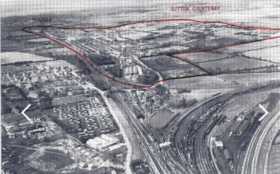


The chunk at the end with the railway junctions became Didcot Power Station ... ... with the the GWR main line running across the bottom of the picture.

The remaining area became Milton Trading Estate, later gentrified as Milton Park. The original Trading Estate entrance was, indeed, where the military used to go in or out, off Milton High Street. But, if we were to drive on to the southern end of the High Street we should see that things have got a lot bigger.
 Here is just part of the much prettified Milton Park "industrial" estate.
 Milton village is at the top, the green sheds (left) mark the old RAF entrance and the old Trading Estate entrance. Bottom left is the junction with a rejigged A34. The whole Milton Park is shown below. (click on the image to enlarge it)
 The Great Western Railway is running dead straight across the bottom of the various sheds and offices,


But well hidden round the back of the new and trendy business and innovation park, you will find remnants of its military past, notably old gates covered in undergrowth ...

... and on Pembroke Road, accessed from Milton Village, you can see the remnants of the corrugated iron fencing that originally surrounded the whole RAF site.

So tomorrow we will look at bus services to Milton Park; but only after wondering whatever happened to the power station.
Google Earth suggests that it is no more.


It doesn't even offer a time point for the almost forgotten Milton Village but it is between Sutton Courtenay and Milton Park.
More Autonomous Bus background tomorrow.
Next Milton Park blog : Tuesday 7th March
No comments:
Post a Comment