
When fbb was looking at Stuttgart, he reminded readers that train, stadtbahn and bus services were all grouped together into one integrated network with a unified ticket system. Fares are based, understandably, on a zonal system but one ticket at one price is then valid on all services, irrespective of mode.
Stuttgart has two maps, one for buses only with rail and stadtbahn as grey lines. The other is just the two rail networks with no mention of buses.
This has NEVER been the case in London where London Transport (in its varied guises) has operated the "Underground" and the bus network. These two come under Transport for London (TfL) for which the mega-mayor has overall responsibility.

TfL has responsibility for London's network of principal road routes, for various rail networks including the London Underground, London Overground, Docklands Light Railway and TfL Rail. It does not control National Rail services in London, however, but does for London's trams, buses and taxis, for cycling provision, and for river services.

Although Oyster, Contactless and Travelcards have helped to glue the systems together there is still a complex mixture of fares systems and availability.
One of these involves the use of the mysterious PINK touch in/out Oystercard readers.

Thankfully, there is an unofficial YouTube video that explains all this.
A journey across Zone 1 (using Oyster) ...
... costs £2.80 but the same journey round Zone 1 ...

... and entirely in Zone 2 costs £1.50 - although the TfL journey planner says £2.80. To get the cheaper price you have to prod the pink. But the video goes on the advise that some journeys, especially from stations that have recently been absorbed from National Rail, touching the pink reader means you pay more.
Aaargh!
No 3 son, who has both lived and worked in London, explains that Oyster Card holders just don't care any more and let the technology do its worst (or better).
And the bus journey (very sl-o-o-o-ow) is ...

... more expensive!
But if you do not use Oyster, things are even more expensive. A Zone 1 Underground fare without Oyster between London Bridge and Kings Cross St Pancras is £4.90 ...
 ... but on Thameslink trains (National Rail) the same journey is just £3.10.
 But the cheaper route is not shown on the "Tube" map and an innocent visitor might not know that it was available.
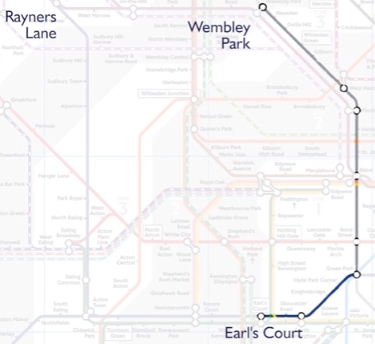
Or take a journey that IS on the map. Wimbledon to Waterloo. The TfL journey planner gives the correct and sensible answer at an Oyster fare ...
 But if you followed the map ...
 ... it will take longer and cost your more. The simplest and frequent route by South Western Railway is not on the map.
 The non Oyster fare is, of course, higher.


Or take a journey that IS on the map. Wimbledon to Waterloo. The TfL journey planner gives the correct and sensible answer at an Oyster fare ...


The "card map" includes the Croydon tram network but trams are not included in the Zone system. So a trip from Waterloo to Mitcham Junction by train all the way is £3.00 ...


... by train and tram is £4.20 ...
 ... and by "Tube" and tram is complicated and £4.30.
 Of course, some of these options would not normally be used but the fully integrated system in Stuttgart would not be bothered by that. The fares would, generally, be the same irrespective of mode and route used.
The problem at the heart of these multiple anomalies is that the fares system is trying to squeeze together different businesses with their individual financial responsibilities plus a need (either real or aspirational) to show a profit!
Which challenges the whole philosophy of the "Tube" map.
Should it be an "Oystercard" map?
Should there be a concerted effort to create a unified network, unified fares and then a unified map?
Or are we stuck with confusion and complexity?
What about the "London Network" map showing Tube and Rail?
Or is the answer that it simply doesn't matter as most people are regular "commuters" and anomalies outside of home work travel simply do not bother people?
And fbb does realise that the Mayor (or Transport for London) would like to take over the whole of the former Network Southeast but the DaFT (Department for Transport) won't let them.
 You do wonder whether the growth of passenger numbers and frequencies on the Overground Network might be replicated elsewhere under TfL management.
There are some challenging questions which will, sooner or later, need to be answered.
Tomorrow, another question. What IS an interchange?

The problem at the heart of these multiple anomalies is that the fares system is trying to squeeze together different businesses with their individual financial responsibilities plus a need (either real or aspirational) to show a profit!
Which challenges the whole philosophy of the "Tube" map.
Should it be an "Oystercard" map?
Should there be a concerted effort to create a unified network, unified fares and then a unified map?
Or are we stuck with confusion and complexity?
What about the "London Network" map showing Tube and Rail?
Or is the answer that it simply doesn't matter as most people are regular "commuters" and anomalies outside of home work travel simply do not bother people?
And fbb does realise that the Mayor (or Transport for London) would like to take over the whole of the former Network Southeast but the DaFT (Department for Transport) won't let them.

There are some challenging questions which will, sooner or later, need to be answered.
Tomorrow, another question. What IS an interchange?
Next Tube Map blog - Friday 9th November
I think FBB is rather over thinking the issue here and finding a problem which doesn't exist.
ReplyDeleteOn fares, I wonder how many actually pay for a journey, and how many have a rover (by whatever marketing name)? And isn't Oyster capped at a maximum daily rate? Either way, whilst the variance in fares may irk, does it really matter to the public? I remember a tale from over five years ago told by the owner of a local medium sized bus company who was out driving one day. A 16 or 17 year old dropped a coin as he paid his fare and it rolled off the gently sloping platform, hit the kerb and went under the bus. The driver offered to move the bus back to recover the coin "don't bother mate, its only a quid".
As for the name of the map, "Tube" pretty much does it, at least for the public. If it changes to "Tube and Rail" what about the sub-surface underground lines? Or the trams? No, "Tube" is the term the public use, Overground is now part of that network and TfL want it to be seen as that. Add in what was once considered a railway, but now is closer to a "Tube" and the distinction is further blurred. We will see a class 345, a high percentage of the passengers on a 345 will, TfL hopes, see it as a "Tube".
When it comes to names for the publication, I rather liked the word "Diagram" on the vintage version shown yesterday; but again nothing really beats "Tube Map" however incorrect that is in strict dictionary terms.
For 'Oyster Card' one can now read contactless bank card, which almost everyone will have even if resident in the sticks - so the number of passengers paying (e.g.) £4.90 for a Zone 1 tube ride is surely now infinitesimal?
ReplyDeleteLondon with population at ~9m is rather bigger than Stuttgart at ~700,000.
ReplyDeleteBuses are slow and cheap, trains are more expensive, but faster and the tube is in the middle. You pay for speed and in a big city that matters. Also buses have a flat fare per bus ride (or hopper fare), but trains are zone to zone if you interchange within a station (ie staying travelling). Pink touch points only occur at certain Underground interchanges to determine route.
The components get complicated, but most journeys are paid for by Contactless bank card or Oyster card. Oyster cards are now more used for season tickets / age discounts / NR Railcard discounts etc. with Contactless for adult pay as you go. They both have daily and weekly maximum charges, which is what many people actually pay. The individual single fares are usually not relevant and so anomalies within the complex network don’t matter. Cash is only usable to top up Oyster cards or buy train tickets from machines; buses and trams only take cards and station barriers only take cards or tickets. Most Travelcards are redundant.
If you want complicated fare tables consider Oyster cards fares from NR stations beyond zone 9, like Hertford East. Hertford East to Hertford North is an official interchange with a good 20 minute walk!
National Rail for years has produced a map (diagram) with London's Rail and Tube services (ie all rail) on one side and London & the South East rail services on the other. These days it has the fare zones and the Oyster card boundary. Stations like Watford Junction and Gatwick Airport are outside zone 9, but now take Oyster cards. Zones 7,8 & 9 are also outside Greater London.
ReplyDeleteThe central tube is overcrowded and the new maps are trying to persuade people to use other routes or plain walk.
The pink readers may be few in number (at just 16 stations, mostly Overground), but are hardly mysterious. There are references to them on the Fares & Tickets and Oyster pages of the TfL website and in proper printed leaflets, as well as signs at stations where necessary.
ReplyDeleteAs others have commented, the "tube" map contains the high-frequency, TfL-operated or franchised services people are most likely to use. For everything else there is the London Connections Map, which in my experience is displayed in A0 size posters at stations and on platforms.
Will Overground come to South Eastern? I hope not. As I understand it (track diagram holders please correct me!), Overground services operate on largely segregated tracks, whereas "Network South East" (now SouthEastern Metro) share their (congested) lines with mainline services from the rest of Kent and Sussex. There is no real space for frequency improvements, at least not easily and without years of disruption to manage it.
It Mayor whoever wants to take control of my rail services, then I want a say in who the Mayor is!
R.E. The "tube" map. It is not just high frequency LO services. Those to Cheshunt are not frequent, nor are many people likely to use them. On the other hand those from Wimbledon to Waterloo for example definitely are frequent, and definitely are very well used. It's simply that TFL don't really like to acknowledge the existence of other transport operators.
DeleteValid points about Overground coming to South Eastern - one wonders what the good people of the Thames Valley as far away as Reading will make of the "Tube style" sideways seating on the Elizabeth Line trains!
ReplyDeleteAnd TfL seems to think that it "owns" the Relief Lines from Paddington to Reading despite there being guaranteed freight paths on them, and them being the diversionary route if anything happens on the Main Lines (see recent Channel 5 "Paddington 24/7" programmes).