Sheffield P.S.
Correspondednt Roy has pointed out a bit of a booboo from First (presumably). Service 97 and 98 do NOT stop on High Street in Sheffield Centre. They were banished when Pinstone Street was closed temporarily/permanently (delete where inapplicable). On the previous PTE timetable ...... Arundel Gate is shown correctly, as it is on the PTE map, stop AG123!According to their current web site (as of yesterday) First do not have a service 97/98!
But, showing almost unbeliveable perspicacity, fbb has actually found service 97/98 in First's data. As part of the ongoing policy of Building Back Better, 97/98 are well hidden, filed under school service 798 ...
... where the public has absolutely no chance of finding them! At least THIS version of the timetable has Arundel Gate rather than High Street.
Meanwhuile, First's route map has not been updated and still shows the Totley-bound (southbound) city centre stop as an incorrect High Street, not the correct Arundel Gate.The Arundel Gate "blob" is for northbound journeys.And Nylons?
Two buildings have carried the Brentford Nylons name; one alongside the M4 viaduct ...
... and one on the good old Great West Road.
Neither of them exists today and neither of them is the building featured in the Alan "Fluff" Freeman advert!Moral : don't ever believe a word of what is supplied on any advert! You really can tell Stork for Butter and always could!
Brentford Nylons The purveyor of nylon bedding, shirts and slacks, famous for its iconic 1970s adverts starring Alan Freeman, went into administration in February 1976. The name disappeared from British life after the company was sold in 1997 to become Cramlington Textiles.
Brentford has a bit more history than the M4 viaduct, seen here joining the A4 just east of the river Brent!
The settlement pre-dates the Roman occupation of Britain, and thus pre-dates the founding of nearby London. The quality and quantity of the artefacts suggests that Brentford was a meeting point for pre-Romanic tribes. One well known Iron Age piece from about 100 BC to AD 50 is the Brentford horn-cap, a ceremonial chariot fitting that formed part of local antiquarian Thomas Layton's collection, now held by the Museum of London.
The Celtic knot pattern (the 'Brentford Knot') on this item has been copied for use on modern jewellery - and other items of persoanl adornmernt.Brentford is part of the London Borough of Houslow ...... but the electoral ward of "Brentford" ...... doesn't include a lot of bits that would be classed geographically as the real Brentford.Brentfod Station (served from Waterloo) ...
... most of the River Brent and the site of the Battle of Brentford are all in "Syon", taking its name from Syon house.From a railway point of view, in addition to the extra-curricular Brentford, Kew Bridge just creeps in in the West.
Most meorably, the magnificent Boston Manor, on the Piccadilly Line, is on the very western edge.There are plenty of buses, BUT ...
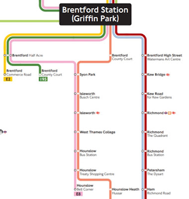
As part of its Building Back Better campaign, Traansport for London has been deleting all maps from its web sites, including many of the marginally useful "Spider" maps. Some of the remaining "spiders" leave a lot to be desired. Everything in the current Brenford arachnid is orientated north and south ...
... with no regard for anything that might just be remotely geographically understandable. "Southbound" is similar.And, of course, we all know what Griffin Park is?
Don't we?


